Entlebuch Emmental High Trail Stage 4: Trubschachen – Grosshorben


- 3:02 h
- 9.09 km
- 616 m
- 129 m
- 729 m
- 1,300 m
- 571 m
- Start: Trubschachen
- Destination: Grosshorben
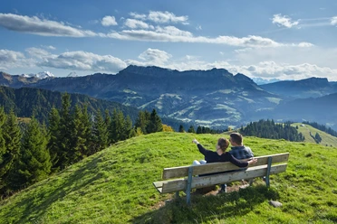
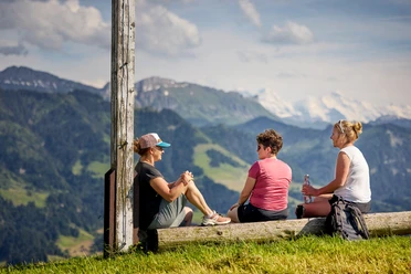
The fourth stage of the Entlebuch-Emmental high trail takes you from Trubschachen through the typical hilly Emmental landscape to Grosshorben. The start is in the cozy village of Trubschachen, which is also the home of the world-famous Kambly biscuits. Uphill, you walk along the Napfbergland border trail towards Rämmisgummenhoger, which marks the highest point of the hike. The Rämmisgumme became nationally famous for its beautiful crocus blooms in spring. Thousands of white and purple crocuses stretch towards the sun. Just before Rämmisgummen, you have the opportunity to turn off to the mountain inn Erika to enjoy a refreshment with a great view. From Rämmisgummenhoger, you now follow the ridge, crossing the border between Emmental and Entlebuch from time to time. Here you will find benches to rest and enjoy the fantastic views and panoramas. With a pleasant ascent and descent, you reach the stage destination Grosshorben.
The fifth and final stage takes you from Grosshorben to Schangnau.

Good to know
Pavements
Best to visit
Directions
Stage 4: Trubschachen – Grosshorben
Trubschachen – Bärgenhüsi – Houenenegg – Unter Houenen – Oberhouenen – Chäserenegg – Rämisgummen – Hinter Rämisgummen – Pfyffer – Grosshorben
Ascents and descents:
Egghus Wiggen - Grosshorben: ascent 2 hours, descent 1 hour 40 minutes
Tour information
Nature Highlight
Stop at an Inn
Equipment
Good footwear, rain jacket & enough drinking water for the journey are essential for every hike.
More tips for safe hiking, information about cow-calf herds and livestock guardian dogs, and much more can be found on the Swiss Hiking Routes website.
Directions & Parking facilities
The UNESCO Biosphere Entlebuch lies in the heart of Switzerland, centrally between Bern and Lucerne. By car, you reach the various stages via main road 10.
Plan your route with the help of the Google Route Planner.
At the starting points, there are various free as well as paid parking spaces.
You can reach the various stages by public transport via the Bern-Lucerne railway line.
Plan your trip with the SBB Online Timetable.
Additional information
c/o Biosphere Centre
Chlosterbüel 28
CH-6170 Schüpfheim
Phone +41 (0)41 485 42 50
www.biosphaere.ch
Literature
The brochure "Hiking - Hiking suggestions in the UNESCO Biosphere Entlebuch" is available from the Biosphere Center or in the brochure store at www.biosphaere.ch
Author
UNESCO Biosphäre Entlebuch
Organization
UNESCO Biosphäre Entlebuch
License (master data)
UNESCO Biosphäre Entlebuch

Author´s Tip / Recommendation of the author
Allow some time for a visit to the Kambly biscuit factory. At the Kambly Experience, you will discover not only the origin of our traditional brand but can also sample many varieties of biscuits.
Nearby