Entlebuch Emmental High Trail Stage 5: Grosshorben - Schangnau


- 1:45 h
- 5.16 km
- 196 m
- 487 m
- 928 m
- 1,415 m
- 487 m
- Start: Large shafts
- Destination: Schangnau
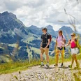
The last stage of the high-altitude trail promises another great view. You hike along the ridge from Grosshorben. Once you reach Wachthubel, it's worth taking a breather. The panoramic benches will enchant you with a fantastic view - the Hohgant seems close enough to touch, but the Schrattenfluh and Sichle are also impressive in size. The snow-covered Bernese Alps are of course not to be ignored. After a last look and a souvenir photo, you now hike moderately downhill to the stage destination of Schangnau. After completing the high-altitude hike, you have well earned a delicious meal here. Gasthof Löwen is located directly in the village. Alternatively, you can take a short Postbus ride and visit the world-famous Kemmeriboden-Bad country inn. However, check the opening times in advance and make a reservation.
Good to know
Pavements
Best to visit
Directions
Stage 5: Grosshorben - Schangnau
Grosshorben -Bergegg - Wachthubel (> descent to Marbach) - Oberi Flue - Meisenegg - Rütiboden - Ob. Rüti - Unt. Lamm - Vord. Scheidbach - Unt. Rüti - Schangnau
Ascents and descents:
- Egghus Wiggen - Grosshorben: Ascent 2 hours, descent 1 hour 40 minutes
- Post Marbach - Wachthubel: ascent 2 hours, descent 1 hour 25 minutes
Equipment
Good footwear, a rain jacket and plenty of drinking water are essential for every hike.
Further tips on safe hiking, information on suckler cow herds and livestock guarding dogs and much more can be found on the Swiss Hiking Trail website.
Directions & Parking facilities
The UNESCO Biosphere Entlebuch is located in the heart of Switzerland, centrally between Bern and Lucerne. You can reach various stages by car via the main road 10.
Plan your route with the help of the Google route planner.
There are various free and paid parking spaces at the starting points.
You can reach the various stages by public transport via the Bern-Lucerne railroad line.
Plan your journey with the SBB online timetable.
Additional information
UNESCO Biosphere Entlebuch
c/o Biosphere Center
Chlosterbüel 28
CH-6170 Schüpfheim
Phone +41 (0)41 485 42 50
www.biosphaere.ch
Author
UNESCO Biosphäre Entlebuch
Organization
UNESCO Biosphäre Entlebuch
License (master data)
UNESCO Biosphäre Entlebuch

Author´s Tip / Recommendation of the author
You can enjoy great views at Wachthubel. Take some provisions with you and enjoy the peace and quiet on the border between Emmental and Entlebuch.
Nearby