- 2:30 h
- 27.96 km
- 995 m
- 995 m
- 686 m
- 1,319 m
- 633 m
- Start: Schüpfheim
- Destination: Schüpfheim
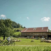
This tour, which boasts some fine views, begins at Schüpfheim station and immediately rises through the Bleikiwald forest to the Finishütte refuge. The route continues to ascend via Fankhus to a restaurant, the Alpwirtschaft Neuhütte. After a brief downhill, you proceed via the Rossweid and uphill again to the Schwarzebergchrüz. The tour continues downhill via the Büelweid to Hasle, then follows the Kleine Emme back to Schüpfheim.
Highlight:
The tour takes you past a number of restaurants and dairies.
Food/drink:
- Alpwirtschaft Neuhütte
- Restaurants in Hasle and Schüpfheim
Good to know
Best to visit
Directions
Tour information
Loop Road
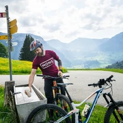
Equipment
Eine gute Ausrüstung inkl. Regen- und Wärmeschutz, Reparatur- und Erstehilfe-Set sind auf einer MTB-Tour immer dabei. Helmtragen ist selbstverständlich und für die Dämmerung ist ein Licht erforderlich.
Directions & Parking facilities
Die UNESCO Biosphäre Entlebuch liegt im Herzen der Schweiz, zentral zwischen Bern und Luzern. Sie erreichen Sörenberg über die Hauptstrasse 10 Richtung Schüpfheim.
Planen Sie Ihre Route mit Hilfe des Google Routenplaners.
Mit dem öffentlichen Verkehr erreichen Sie Schüpfheim via Bahnlinie Bern-Luzern.
Planen Sie Ihre Reise mit dem SBB Online Fahrplan.
Additional information
UNESCO Biosphäre Entlebuch
Biosphärenzentrum
Chlosterbüel 28
CH-6170 Schüpfheim
Tel. +41 41 485 88 50
www.biosphaere.ch
Literature
Die Broschüre «Bike-Guide» finden Sie in digitaler Version via www.biosphaere.ch/broschueren
Author
UNESCO Biosphäre Entlebuch
Organization
UNESCO Biosphäre Entlebuch
License (master data)
UNESCO Biosphäre Entlebuch

Author´s Tip / Recommendation of the author
Probieren Sie den frischen Alpkäse bei der Alp Äbnistetten und geniessen Sie dabei die eindrückliche Aussicht auf Äbnistettenflue und Schafmatt.
Safety guidelines
Tragen Sie die richtige Schutzausrüstung, schätzen Sie Ihr Können richtig ein, gewähren Sie Wandernden den Vortritt, bleiben Sie auf dem Trail und schliessen Sie Weidezäune! Orientieren Sie sich am Bike-Kodex Zentralschweiz - so bleiben Sie auf Ihrem Mountainbike gern gesehen!
Nearby