Höhenweg Entlebuch Emmental Stage 2: Obstaldenegg - Turner
- 3:23 h
- 10.14 km
- 414 m
- 279 m
- 1,040 m
- 1,246 m
- 206 m
- Start: Obstaldenegg, Schüpfheim
- Destination: Turner, Escholzmatt
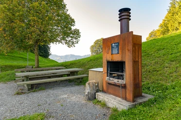
The second stage of the Höhenweg Entlebuch-Emmental leads you from Obstaldenegg in Schüpfheim over the ridge to Turner in Escholzmatt. Always with the fantastic panoramic view. You start the route at the Obstaldenegg barbecue area and immediately enter a forest section. Time and again, you catch a glimpse of the surrounding beauties. For example, the charming St. Joseph Chapel near Oberberg. At Gmeinwärch, a vending machine with cold drinks and snacks is available if you already want to take a first break. On the bench, you enjoy the great view towards Emmental. Now you cross the municipal boundary and continue hiking on Escholzmatt territory. It goes moderately downhill until the next ascent follows into the Rotegg area. Here, forest sections and open terrain alternate constantly. Enjoy the peace on this hiking trail away from the large crowds. At Turner, you reach your stage goal and enjoy the wonderful view.
The third stage takes you over the "border" from Turner in Escholzmatt to Trubschachen.
Waypoints
Good to know
Pavements
Best to visit
Directions
Stage 2: Obstaldenegg – Turner
Obstaldenegg – Gmeinwerch – Mittlisthütte – Champechnubel – Stutzegg – Chrüzbode – Grätliegg – Altegrat – Turner
Ascents and Descents:
- Schüpfheim station - Obstaldenegg: ascent 1 hour 25 minutes, descent 1 hour 10 minutes
- Escholzmatt station - Turner: ascent 1 hour 35 minutes, descent 1 hour 15 minutes
Equipment
Good footwear, rain jacket & enough drinking water for the way belong to every hike.
Further tips for safe hiking, information about suckler cow herds and herd protection dogs, and much more can be found on the Swiss Hiking Routes website.
Directions & Parking facilities
The UNESCO Biosphere Entlebuch is located in the heart of Switzerland, centrally between Bern and Lucerne. By car, you can reach the various stages via main road 10.
Plan your route with the help of the Google Route Planner.
At the starting points, there are various free and paid parking spaces.
You can reach the various stages by public transport via the Bern-Lucerne railway line.
Plan your trip with the SBB Online Timetable.
Additional information
c/o Biosphere Centre
Chlosterbüel 28
CH-6170 Schüpfheim
Telephone +41 (0)41 485 42 50
www.biosphaere.ch
Author
UNESCO Biosphäre Entlebuch
Organization
UNESCO Biosphäre Entlebuch
License (master data)
UNESCO Biosphäre Entlebuch

Author´s Tip / Recommendation of the author
From the stage destination Turner, a detour to the Bock is worthwhile. Here you enjoy a great view of the village of Escholzmatt.
Nearby