Mettilimoos Moor Path


- 4:30 h
- 14.07 km
- 602 m
- 598 m
- 684 m
- 1,285 m
- 601 m
- Start: Entlebuch station
- Destination: Entlebuch station
Finsterwald (above the village of Entlebuch) impresses with a uniquely beautiful moor landscape, which can be enjoyed on numerous paths. In autumn, when the colors of the moor shine particularly beautifully, the natural spectacle is almost perfect. In summer, you can convince yourself of the beneficial effects of the moor in the moor footbath. Nowadays, the moors are protected. Thousands of tons of peat were cut in the Mettilimoos and near Wissenegg during the two world wars and incinerated in the ovens of companies instead of coal. The equipment used for this can be admired in the peat hut in Mettelimoos.
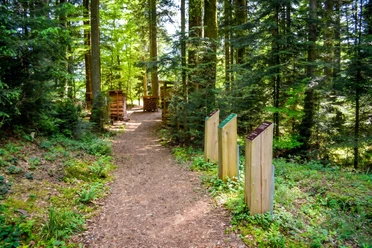
From the station in Entlebuch, you ascend to the church, cross the main road and first follow Glaubenberg Street, then a short section of Lustenberg Street. You now climb directly up the Schluecht. From there, the Mettilimoos can be reached in two ways: via Schluechtberg across a goods road and a field path or via the road that passes by the Egg Chapel (built in 1694). The first and second information boards are located on the road through the Mettilimoos. After a slight ascent, you reach the north side of Schafberg. At the signpost, turn right onto a meadow path. From the Dietenwart-Gräben farmstead, you can either reach the saddle at 1187 m by a steep cart path or more comfortably via a forest road. You then continue uphill, go right at the junction, cross a swampy forest area, and reach Wissenegg. From there, continue about 150 m along the forest edge, then down a narrow forest path to the road to Finsterwald. Along the way, you pass the third and fourth information boards. Continuing, you pass the only natural gas production facility in Switzerland and some peat diggings. In Finsterwald (post bus stop), turn left at the last house onto the path that first follows the forest edge, then merges into a forest road in the Chilenwald. You continue hiking to a prominent fork, turn right and follow a stream to the bridge. Keeping left, you walk past the Burg farms and the Entlebuch castle site, cross the castle moat, and reach the village of Entlebuch on a forest path that later turns into a paved road.
Waypoints
Good to know
Pavements
Best to visit
Tour information
Loop Road
Nature Highlight
Equipment
Spare clothing or at least socks as well as a terry towel are recommended.
Directions & Parking facilities
The UNESCO Biosphere Entlebuch lies in the heart of Switzerland, centrally between Bern and Lucerne. You reach Entlebuch via main road 10. From Sarnen, drive over the Glaubenberg Pass to Entlebuch.
A paid parking lot is available at Entlebuch station.
You can reach Schüpfheim by public transport via the Bern-Lucerne railway line.
Plan your trip with the SBB online timetable.
Additional information
CH-6162 Entlebuch
+41 41 79 651 64 54 (Monday to Friday between 9 and 11 am)
[email protected]
www.tourismus-entlebuch.ch
Author
UNESCO Biosphäre Entlebuch
Organization
UNESCO Biosphäre Entlebuch
License (master data)
UNESCO Biosphäre Entlebuch

Author´s Tip / Recommendation of the author
Would you like to explore the moor with an expert? The UNESCO Biosphere Entlebuch is happy to organize guided tours or excursions. Get information at the Biosphere Center: [email protected] or tel. +41 (0)41 485 42 50.
Nearby


Download GPX file