Charcoal Burner Trail Romoos


- 4:00 h
- 10.96 km
- 799 m
- 539 m
- 792 m
- 1,157 m
- 365 m
- Start: Romoos village square
- Destination: Bramboden village square
If you set out from Romoos and hike through the sprawling Napf area, you might suddenly catch the smell of smoke rising between the trees. Don't worry, it's not a forest fire: it is the fumes of the smoldering charcoal kilns. The charcoal burners of Romoos stack beech, ash, and conifer wood into conical piles. Then they set them on fire to produce charcoal. For about two weeks, they monitor the charring around the clock – producing the «black gold» is hard work.
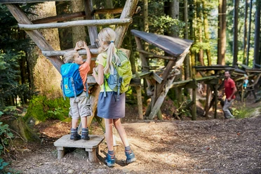
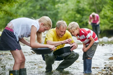
The farmers have been practicing charcoal burning as a sideline for centuries. Once, Romoos had about 200 charcoal sites; back then, farriers, iron foundries, or glassworks needed large amounts of charcoal. Today, only a few farmers from the Napf region keep the ancient craft alive. They produce about 100 tons of charcoal annually. Piercing air holes, adding fuel, drawing out charcoal – with some luck, on the hike between Romoos and Bramboden, you can watch the charcoal burners at work. Panels along the charcoal burner trail also provide information on charcoal burning as well as gold prospectors and natural phenomena in the region.
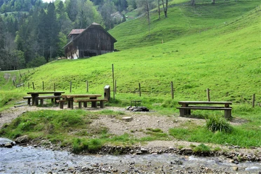
The route first leads uphill to Schwändi and then along a spectacular footpath through the narrow gorge of the Goldbach. The highest point of the hike is reached at Ober Länggrat. The trail via Rose-Beizli, which is slightly off the path, leads down to the Seeblibach and the finish at Bramboden, crossing the Lucerne Napf region. You pass steep conglomerate cliffs and waterfalls, narrow ravines, and sunny ridges. Because of its topography, the area around Romoos is also called the «Centovalli of the canton of Lucerne». Bramboden is a true gem – it lies in a side valley in the Entlebuch, far away from all other villages. In the pilgrimage site, it's worth visiting the charming mountain church dedicated to Saint Anthony of Padua.

Waypoints
Good to know
Pavements
Best to visit
Directions
Romoos village square - Bodengade - Studewald - Zällerhüsli - Schwändi - Länenwald - Under Länggrat - Ober Länggrat - Gadenstattli - Geissboden - Drachslis - Luegmoos - Bramboden village square
Tour information
Cultural Interesting
Stop at an Inn
Equipment
Good footwear, rain jacket & enough drinking water for the journey are essential for every hike.
More tips for safe hiking, information on suckler cow herds and livestock guardian dogs and much more can be found on the website of Swiss Hiking Routes.
Directions & Parking facilities
By car, drive from Wolhusen LU towards Entlebuch and turn off at the Schwanderholzstutz viaduct towards Doppleschwand and Romoos. When you arrive in the village of Romoos, you will see the distinctive signpost fountain. Turn right before this fountain, drive past the church to the public parking lot below the schoolhouse. You can park your car there free of charge.
In Bramboden you have connections to public transport on weekends.
Free parking spaces at Romoos schoolhouse.
From Wolhusen (Lucerne-Bern rail line) you can reach Romoos by post bus. Get off at the post stop «Romoos Post». You are now at the village square, the starting point of the charcoal burner trail.
From Bramboden, Kirchplatz the post bus runs to Schüpfheim on weekends.
Additional information
Would you like to watch how a charcoal kiln is built and charcoal is produced? The UNESCO Biosphere Entlebuch gladly organizes guided excursions. For information, contact the Biosphere Center at [email protected] or tel. +41 (0)41 485 42 50.
Information about charcoal burning
Information about the Charcoal Burner Support Association Romoos
Recommended reading: Nina takes you along the charcoal burner trail in her blog post
Author
UNESCO Biosphäre Entlebuch
Organization
UNESCO Biosphäre Entlebuch
License (master data)
UNESCO Biosphäre Entlebuch

Author´s Tip / Recommendation of the author
Did you know that there is a film about charcoal burning in Romoos? Everything about the film and more exciting information can be found at www.koehlerei.ch
Nearby


