Bramboden-Napf


- 2:15 h
- 7.03 km
- 383 m
- 31 m
- 1,053 m
- 1,405 m
- 352 m
- Start: Village Bramboden
- Destination: Napf
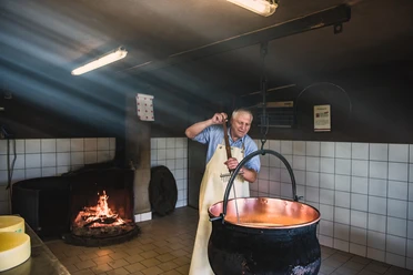
A look at the hiking map shows you that the Napf is practically star-shaped with hiking trails. The viewpoint on the Bern-Lucerne border is excellently accessible from both sides. However, it can only be reached on foot. The starting point of our route is Bramboden. With PostAuto line no. 234 you reach Bramboden from Schüpfheim via Hasle. A short stay here is also worthwhile, as the internationally renowned chef Stefan Wiesner has pitched his tents here. Besides gourmet menus, there is also the Weitsicht-Treff, a self-service restaurant, in the Wiesner Mysterion.
A newly created charcoal burning room in the Entlebuch hamlet of Bramboden (LU) also invites hiking enthusiasts to encounter the old craft of charcoal burning. A 270-degree panorama shows atmospheric images of charcoal production. Close-ups of the various materials and stages of the charcoal burning process are combined with sounds.
Once you are ready to start your hike, the path leads from the church first on a small road, soon but on gravel paths heading west, past several farms to the cantonal border where it turns north. Short climbs alternate repeatedly with longer flat sections offering beautiful views of the varied structured landscape of the Napf area: deeply incised ravines alternate with wooded steep slopes and narrow but sunny ridges. Over the Trimlegrat you reach the Stächelegg, where there is an impressive deep view into the Änziloch. According to legend, evil spirits dwell here, who are especially mischievous during thunderstorms. After a last ascent, you reach the Napf.
From the Napf you can return on numerous hiking trails to Romoos, Schüpfheim, Luthern Bad, Menzberg, Trub, etc.
Waypoints

Good to know
Pavements
Best to visit
Directions
Bramboden - Hofarni - Oberratshuse - Stächelegg - Napf
Tour information
Cultural Interesting
Stop at an Inn
Equipment
Good footwear, a rain jacket & enough drinking water for the journey are part of every hike.
Further tips for safe hiking, information about mother cow herds and herd guardian dogs, and much more can be found on the website of the Swiss Hiking Trails.
Directions & Parking facilities
The UNESCO Biosphere Entlebuch lies in the heart of Switzerland, centrally located between Bern and Lucerne. You reach Bramboden via main road 10 towards Entlebuch and from there towards Doppleschwand. After a long straight stretch, a steep left curve follows, after which there is a junction on the left side. Turn left and from here follow the signs to Bramboden.
Plan your route using the Google route planner.
Several free parking spaces are available in Bramboden.
By public transport, you can reach Bramboden via Hasle (Bern-Lucerne railway line). From Hasle, take the PostBus to Bramboden "Kirchplatz". Plan your trip with the SBB online timetable.
Additional information
Tourism office Romoos
c/o municipal administration
Dorf 32
CH-6113 Romoos
Phone +41 41 480 28 00
www.romoos.ch
Author
UNESCO Biosphäre Entlebuch
Organization
UNESCO Biosphäre Entlebuch
License (master data)
UNESCO Biosphäre Entlebuch

Author´s Tip / Recommendation of the author
At the start of the hike is the Wiesner Mysterion - a Michelin-starred kitchen amidst nature. Whether gourmet menu, workshop food, or even self-service at the Weitsicht-Treff, the Wiesner Mysterion offers space for hikers, gold prospectors, and gourmet guests.
Nearby


