Circular hike Gfellen-Schimbrig


- 5:20 h
- 14.42 km
- 875 m
- 875 m
- 989 m
- 1,815 m
- 826 m
- Start: Gfellen near Finsterwald (Entlebuch)
- Destination: Gfellen near Finsterwald (Entlebuch)
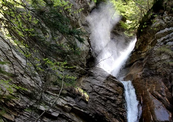
From Gfellen, follow the Grosse Entlen river to the Stilaub bridge. Cross the river and follow the hiking trail on the right side towards Schimbrig. At the beginning, you have your destination, the Schimbrig, clearly in sight before the path leads you in zigzags up the steep meadow slope. After about 30 minutes, you reach Alp Understettili. From there, follow the farm road. Shortly before Schimbrigbad, you may notice a somewhat special smell. This is the sulphur spring. Dare to take a sip of the healing spring water.
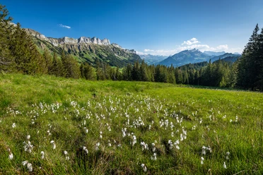
From Schimbrigbad, walk up a meadow path to the edge of the forest. Cross the forest in zigzags. Here, between the trees, you can already catch the wonderful view of Entlebuch. Now follows the most spectacular part of the hike. The last 160 meters of elevation to the summit are mostly on the ridge. At first, young trees line the ridge, but the last meters lead you along the bare, grass-covered ridge. From here, you have a great view of Titlis and the Bernese Alps. Lake Lucerne is also visible on the right side of the ridge. Shortly before the summit, a pasture fence crosses the ridge. A gate gives you free access to the nearby summit cross. Enjoy the panoramic view!
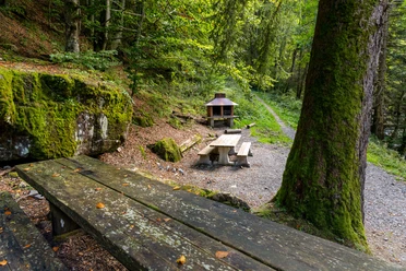
After a short break, return along the ridge the same way. Shortly before the path leads back into the forest, climb over the fence on the left side using a small ladder. From here, descend in 15 minutes to Alp Loegg. Along the way, you will find a bench, which is ideal for a short stop to enjoy the view. From Alp Loegg, walk across the meadow for 20 minutes, descending more than 200 meters to Alp Chätterech. From there, follow the farm road and steadily descend to Alp Grund. From there, the path leads for about two kilometers along the Grosse Entlen river, with the last 300 meters on an asphalt path. Cross the river over an old wooden pedestrian bridge and follow an ascending forest path. At the height, pass Alp Brüderen with its small chapel. From here, the Hermit’s Path leads through a holiday home settlement down to the starting point Gfellen.
Waypoints
Good to know
Pavements
Best to visit
Directions
Gfellen - Stillaub - Understettili - Alp Stettili - Schimbrigbad - Schimbrig - Alp Loegg - Alp Chätterech - Grund - Brüederealp - Gfellen
Tour information
Loop Road
Equipment
Good footwear, a rain jacket & enough drinking water for the journey are essential for every hike.
More tips for safe hiking, information about cow-calf herds and livestock guardian dogs, and much more can be found on the website of Swiss Hiking Trails.
Directions & Parking facilities
The UNESCO Entlebuch Biosphere is located in the heart of Switzerland, centrally between Bern and Luzern. You reach Gfellen via main road 10 towards Entlebuch and from there to Finsterwald and Gfellen. From Sarnen over the Glaubenberg Pass to Gfellen.
Plan your route using the Google Route Planner.
Paid parking spaces are available in Gfellen.
You can reach Gfellen by public transport via Entlebuch (Bern-Lucerne train line). From Entlebuch, take the post bus to Gfellen.
From early May to the end of October, the post bus (Line 60.232) runs five times on weekends and public holidays and twice from Monday to Friday from Entlebuch over the Glaubenberg Pass to Langis.
Plan your journey with the SBB Online Timetable.
Additional information
Author
UNESCO Biosphäre Entlebuch
Organization
UNESCO Biosphäre Entlebuch
License (master data)
UNESCO Biosphäre Entlebuch

Author´s Tip / Recommendation of the author
Stop for a break at "Gründli" on the way back. From here, there is also the possibility to return to Gfellen by post bus – please check the timetable before your journey as there are only a few post bus services per day.
Safety guidelines
The hike requires surefootedness.
Nearby
Download GPX file