


- 2:10 h
- 6.30 km
- 45 m
- 1,090 m
- 1,242 m
- 2,328 m
- 1,086 m
- Start: Brienzer Rothorn
- Destination: Schönebode car park
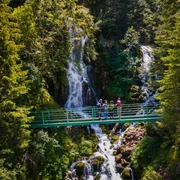
The starting point of the hike is on the ridge of the Brienzer Rothorn, which you can easily reach by aerial cableway: fantastic views of Brienz, Lake Brienz and the Bernese Alps. Descend towards Lake Eisee and from there towards Schönebode.
Good to know
Pavements
Best to visit
Directions
Brienzer Rothorn - Eisee - Schönenboden
Tour information
Mountain Railway Tour
Stop at an Inn
Equipment
Directions & Parking facilities
Additional information
Author
Sörenberg Flühli Tourismus
Organization
UNESCO Biosphäre Entlebuch
License (master data)
Sörenberg Flühli Tourismus

Author´s Tip / Recommendation of the author
During the last third of the walk, make a detour to the Emmensprung. It's well worth it!
Safety guidelines
Map
You can find the hike in the hiking panorama map of Sörenberg-Flühli Toruismus. You can download or order it in the brochure store.
Nearby


