Eremitenweg - circular route between Gfellen and Alp Brüedere


- 1:15 h
- 3.71 km
- 93 m
- 92 m
- 989 m
- 1,082 m
- 93 m
- Start: Gfellen, Finsterwald (Entlebuch)
- Destination: Gfellen, Finsterwald (Entlebuch)
The stroller-friendly circular route starts at the Restaurant Gfellen. Follow the first 200 meters of the road towards Glaubenberg. The path then leads you into a wooded area. The next 800 meters you can stroll comfortably along the Grosse Entle to the Stillaubrücke. Now it is not far! The next quarter of an hour takes you up to the Brüedere Alp.
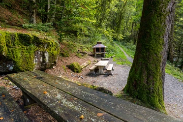
Along the way you can make a detour to the waterfall or to the picnic & barbecue area. In the long left curve, follow the small natural path. Soon you will hear the roar of the waterfall.
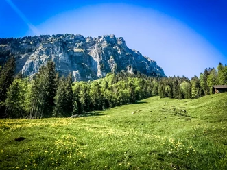
Enjoy the peace at the Brüedere Alp, a hermit settlement from the 15th century. Visit the oldest alpine chapel in the canton of Lucerne, built in 1725, and try a sip of the spring water, which is collected behind the house in a beautiful wooden fountain. With a bit of luck, you may also spot the golden eagle, which nests in the cliff above the Brüedere Alp.
Strong and refreshed, you take on the last stage of about 20 minutes. On the way, you cross the Eibach and pass the small holiday home settlement above the Restaurant Gfellen, where the hike ends again.
There are information boards on history, culture, and nature in three places. Stroller-friendly walk with only a few slopes and many seating options, ideal for seniors.
Waypoints
Good to know
Best to visit
Directions
Gfellen- Stillaubrücke-Brüederesagi-Brüedere-Ober Brüederemättli-Gfellen
The Eremitenweg is marked with cairns and equipped with boards about history, culture & nature.
Tour information
Cultural Interesting
Familiy-Friendly
Loop Road
Equipment
Good footwear, rain jacket & enough drinking water for the journey are part of every hike.
More tips for safe hiking, information about suckler cow herds and livestock guardian dogs, and much more can be found on the Swiss Hiking Federation's website.
Directions & Parking facilities
The UNESCO Biosphere Entlebuch is located in the heart of Switzerland, centrally between Bern and Lucerne. You can reach Gfellen from Lucerne via main road 10 towards Entlebuch and from there to Finsterwald and Gfellen. From Sarnen you drive via the Glaubenberg Pass to Gfellen.
A paid parking lot is available at the Restaurant & Hotel Gfellen.
You can reach Gfellen by public transport via Entlebuch (Bern-Lucerne train line). From Entlebuch, take the post bus to Gfellen.
Plan your trip with the SBB online timetable.
Additional information
Tourism Entlebuch Municipality
CH-6162 Entlebuch
+41 41 79 651 64 54 (Monday to Friday between 9 and 11 am)
[email protected] / www.tourismus-entlebuch.ch
Literature
The brochure "Hiking - Hiking suggestions in the UNESCO Biosphere Entlebuch" can be downloaded here or ordered from the Biosphere Center.
Author
UNESCO Biosphäre Entlebuch
Organization
UNESCO Biosphäre Entlebuch
License (master data)
UNESCO Biosphäre Entlebuch

Author´s Tip / Recommendation of the author
Don't forget the barbecue supplies! Because just before the waterfall there is a barbecue & picnic area that invites you to stay.
Safety guidelines
Each year on the third weekend of August, the Entlebuch hunting shooting takes place in the Gfellen area. The Eremitenweg is fully accessible; however, noise emissions are to be expected.
Nearby

Download GPX file