Glaubenbielen - Sattelpass - Seewen - Stäldili - Flühli


- 6:10 h
- 20.15 km
- 411 m
- 1,092 m
- 882 m
- 1,811 m
- 929 m
- Start: Glaubenbielen parking lot
- Destination: Village center Flühli
The hike from Glaubenbielen to the Sattelpass and from there via Seween to Flühli is a long hike through breathtaking moorland landscapes in the Entlebuch Biosphere. Moors are among the rarest and most valuable habitats in Switzerland. In the UNESCO Entlebuch Biosphere there are a total of 46 raised and transitional moors as well as 68 low moors of national importance with an area of about 26 km².
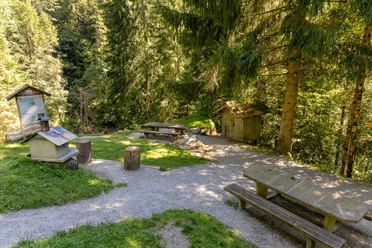
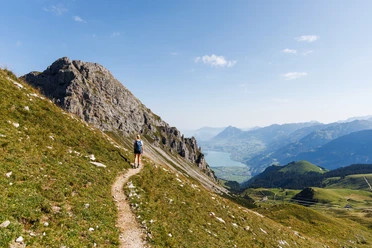
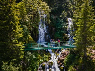
The hiking route starts at the Glaubenbielen parking lot and leads towards Sattelpass further via Miesenegg to Sewenseeli. Above the Sewenseeli there is a small chapel with several resting benches. Enjoy the fantastic wide view here during a longer break – it is worth it. From Sewen you hike uphill again through fascinating moor landscapes to. From there you reach via alpine pastures and forests the Chessimätteli suspension bridge. The 65-metre-long bridge towers high above the Chessloch gorge. So close your eyes and get through it, before there is a short detour of 10 minutes to the Chessiloch waterfall. Afterwards you hike via Kragen to Hüttlenen and after carefully crossing the main road along the Emmen river path into the village Flühli.
In the Glaubenberg/Wasserfallen area there are various Swiss army shooting ranges. Detailed information and details about the shooting dates can be found under "Safety instructions".
Waypoints
Good to know
Pavements
Best to visit
Directions
Glaubenbielen - Rübihütte - Ror - Loo - Sattelpass - Sattel - Miesenegg - Sewen - Blattli - Stäldeli - Holzhack - Eggli - Kragen - Hüttlenen - Flühli
Tour information
Nature Highlight
Stop at an Inn
Equipment
Good footwear, rain jacket & sufficient drinking water for the way belong to every hike.
More tips for safe hiking, information about suckler cow herds and livestock guardian dogs and much more can be found on the website of the Swiss Hiking Routes.
Directions & Parking facilities
The UNESCO Entlebuch Biosphere is located in the heart of Switzerland, centrally between Bern and Lucerne. You reach Sörenberg via main road 10 towards Schüpfheim and from there to Flühli Sörenberg. From Giswil via the panorama road / Glaubenbielen pass to the pass height / parking lot.
Plan your route using the Google Route Planner.
A paid parking area is available at the Glaubenbielen pass height.
By public transport you reach Sörenberg via Schüpfheim (Bern-Lucerne railway line). From Schüpfheim you take the post bus to Sörenberg "Glaubenbielen, parking lot". Note, there are only a few trips per day to the Glaubenbielen Pass.
Plan your journey with the SBB Online Timetable.
Additional information
Sörenberg Flühli Tourism
Rothornstrasse 21
CH-6174 Sörenberg
Phone +41 (0)41 488 11 85
www.soerenberg.ch
Author
Sörenberg Flühli Tourismus
Organization
UNESCO Biosphäre Entlebuch
License (master data)
Sörenberg Flühli Tourismus

Author´s Tip / Recommendation of the author
At Seewenseeli you can enjoy the fantastic view – at the small chapel there are several benches to rest.
Safety guidelines
Important info:
In the Glaubenberg/Wasserfallen area there are various Swiss army shooting ranges. Detailed information and details about the shooting dates can be found here. Entering the dangerous area is life-threatening and therefore prohibited. Follow the instructions of the barrier posts.
Map
Official map of the Swiss hiking trails 1:33'333 «Napf-Sörenberg», ISBN number 978-3-302-33321-2
The brochure «Hiking» with many interesting hiking suggestions is available at Sörenberg Flühli Tourism or in the brochure shop at www.soerenberg.ch
Nearby


